

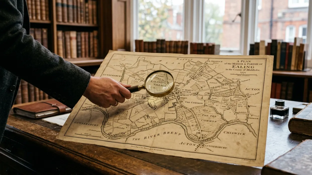
Ealing today is a lively West London borough filled with busy roads, residential neighbourhoods, parks, railway stations, shops and cultural attractions. Yet the landscape looked remarkably different several centuries ago. Historic maps of Ealing provide one of the clearest ways to understand this transformation, showing how small villages, rural lanes, fields, estates and waterways gradually developed into the urban communities people know today.
Looking at an old map is more than an exercise in studying streets and place names. Maps can reveal how people lived, travelled and used the land, as well as how transport, housing, industry and population growth reshaped the area. For local residents, historic maps can make familiar streets feel new again. For tourists and history enthusiasts, they offer a fascinating way to understand Ealing beyond its modern attractions.
Why Historic Maps Are Important for Understanding Ealing
Historic maps provide a visual record of landscape change. Written histories can describe the growth of a town, but a map can show exactly where roads, fields, streams, buildings and estates were positioned at a particular point in time.
This makes historic cartography particularly useful for understanding Ealing’s development. A modern road may follow the route of a much older lane, while a housing estate may occupy land that was once farmland. A park may have developed from a private estate, and a railway line may have transformed a previously rural landscape.
Maps also allow different periods to be compared. By placing an eighteenth-century map alongside a nineteenth- or twentieth-century map, researchers can identify patterns of expansion and change. The transformation becomes much easier to visualise.
For someone exploring Ealing today, this creates an interesting question: what existed here before the buildings, roads and transport networks became familiar parts of the borough?
Ealing Before Large-Scale Urban Development
For much of its earlier history, Ealing was considerably more rural than it is today. The landscape included agricultural fields, country estates, woodland, streams, farms and scattered settlements.
The historic parish of Ealing developed around a village environment rather than the densely populated urban landscape seen today. Areas that now contain rows of houses and commercial buildings once formed part of a much more open countryside.
Historic maps can reveal this rural character through field boundaries and open spaces. Instead of seeing continuous streets, you may find irregular fields connected by narrow lanes and paths. Buildings are often concentrated around established settlements, estates and important routes.
This rural background helps explain why certain parts of modern Ealing still contain traces of older landscape patterns. A road alignment, boundary or unusual curve in a street can sometimes preserve the shape of a much earlier feature.
The Growth of Ealing Village
Ealing’s historic village was an important focus of local development. Its position west of central London made it accessible while retaining a distinct relationship with the surrounding countryside.
Over time, the village expanded and became increasingly connected to London’s growing urban economy. Historic maps can show how buildings gradually became more numerous around established routes.
This transformation was not immediate. Urbanisation usually happened in stages, with individual houses, institutions and developments appearing before continuous streets connected them.
For modern visitors, exploring the older parts of Ealing with a historic map can therefore become a form of time travel. A street that appears completely ordinary today may have followed a route that existed when the surrounding landscape was largely rural.
How Transport Changed Ealing
Few factors influenced Ealing’s development more dramatically than transport. Roads had long connected settlements, but the arrival and expansion of rail transport fundamentally changed how people could travel between Ealing and central London.
Railways encouraged residential development because people could live further from their workplaces while still travelling into London. New stations increased accessibility and helped attract residents, businesses and investment.
Historic maps from different periods can make this transformation particularly clear. Earlier maps may show fields and isolated buildings where later maps reveal railway lines, stations and growing residential districts.
The arrival of rail transport also affected the pattern of roads and development. Streets increasingly formed around stations and routes that connected new neighbourhoods with established centres.
This is one reason Ealing’s railway history is so closely connected with its urban history. Transport did not simply make existing communities easier to reach; it helped create the conditions for their expansion.
Mapping Ealing’s Historic Estates and Parks
Historic maps can also reveal the importance of large estates in shaping Ealing’s landscape. Private estates often occupied substantial areas of land and included houses, gardens, agricultural fields, woodland and landscaped grounds.
Walpole Park provides an excellent example of how historic land use can survive within a modern urban setting. Its association with Pitzhanger and the former estate landscape demonstrates how private land could eventually become an important public green space.
Gunnersbury Park provides another fascinating case. The historic estate landscape has evolved over time, but its surviving parkland offers a physical reminder of the large estates that once occupied parts of West London.
Historic maps help explain the relationship between these estates and the surrounding neighbourhoods. They can show former boundaries, carriageways, gardens and land that later became roads or housing.
From Fields to Residential Streets
Perhaps the most dramatic transformation visible on historic maps is the conversion of agricultural land into residential neighbourhoods.
As London’s population grew, demand for housing increased. Fields surrounding established villages were gradually divided into plots and developed. New streets were laid out, houses were constructed and services followed.
On an older map, a large open field may occupy an area that today contains hundreds of homes. A later map may show the first roads appearing, followed by increasingly dense development.
This process helps explain the layout of many Ealing neighbourhoods. Some streets follow planned patterns associated with Victorian and Edwardian expansion, while others retain older irregular routes.
For residents, comparing historic and modern maps can be a fascinating way to discover what once stood beneath their neighbourhood. The local street may have a history stretching back much further than its present buildings suggest.
Hanwell, Northfields and West Ealing Through Old Maps
Historic maps are particularly useful for understanding how different parts of the wider Ealing area developed.
Hanwell retained elements of its village and rural identity while gradually becoming more integrated into the expanding London region. Its relationship with the River Brent, transport routes and surrounding open land can be understood more clearly through historical mapping.
Northfields also changed substantially as residential development expanded. Earlier maps show a landscape with significant areas of open land, while later editions reveal the growth of streets, houses and transport connections.
West Ealing developed into an important residential and commercial area as transport and population growth increased. Comparing maps from different periods can show how established roads became surrounded by increasingly dense development.
These comparisons demonstrate that Ealing did not grow as one uniform settlement. Different neighbourhoods developed at different speeds and for different reasons.
The River Brent and Lost Landscapes
Waterways are another feature that historic maps can help uncover. The River Brent and associated streams, drainage channels and water features influenced settlement and land use.
Some waterways were altered, diverted, covered or incorporated into modern infrastructure as the urban landscape expanded. Consequently, historic maps may reveal water features that are difficult to recognise today.
The same applies to ponds, field boundaries, footpaths and drainage systems. Features that have disappeared from the modern landscape may remain visible in historical records.
This makes old maps particularly valuable for researchers interested in lost landscapes. They can provide clues about why a modern road bends in a certain direction or why a boundary appears unusual.
How to Read a Historic Map of Ealing
Historic maps can look complicated at first, especially when they contain unfamiliar symbols and old forms of lettering. The easiest approach is to begin with features that remain recognisable today.
Look for major roads, rivers, churches, railway lines, parks and other permanent landmarks. Once these have been identified, compare the surrounding landscape with a modern map.
Pay attention to field boundaries, building footprints and road names. A field may have disappeared, but its boundary may survive as the alignment of a modern street.
It is also useful to check the date and scale of a map. A large-scale map can show individual buildings and boundaries, while smaller-scale maps provide a broader view of regional development.
Where Can You Find Historic Maps of Ealing?
Historic maps can be found through libraries, archives, historical societies and digital map collections. The National Library of Scotland’s online map collection, for example, provides access to many historical Ordnance Survey maps covering parts of Britain.
The British Library and local archives can also be valuable resources for researching historical landscapes, while Ordnance Survey mapping provides an important record of changing geography.
For Ealing-specific research, local history collections can be particularly useful because they may contain photographs, documents, maps and information about individual neighbourhoods.
Digital resources have made this research much easier. Instead of travelling to an archive immediately, you can often begin by comparing historical map scans online with a current digital map.
Using Historic Maps for a Walking Tour
One of the most enjoyable ways to use historic maps is to take them outdoors. Choose an area with a strong historical connection and compare the map with what you see around you.
For example, you might explore central Ealing and look for surviving historic buildings, older road alignments and former estate boundaries. Another route could focus on Hanwell and the River Brent, using historical mapping to identify changes in waterways and surrounding land.
The key is to avoid treating the map simply as a navigation tool. Look for evidence of the past in the present landscape.
A modern street corner may correspond to a former field entrance. A park boundary may follow an old estate edge. A railway station may occupy land that was once open countryside.
This approach turns an ordinary walk into an interactive history lesson.
Why Historic Maps Matter to Local Residents
For Ealing residents, historic maps can create a stronger connection with place. Knowing how a neighbourhood developed can make familiar streets more meaningful.
Maps can answer questions that naturally arise during everyday life. Why does a particular road curve? Why is a park shaped unusually? Where did a local name come from? Was the area always residential?
These questions can lead to fascinating discoveries.
Historic mapping is also useful for family history. If someone is researching where an ancestor lived, an old map can help place a historical address within its wider landscape and identify nearby roads, institutions or landmarks.
What Ealing’s Maps Reveal About Urban Change
The biggest lesson from historic maps is that cities are constantly changing. Ealing’s present landscape is the result of centuries of decisions involving land ownership, transport, housing, economic activity and public planning.
Some features disappeared completely, while others survived in altered forms. Roads changed names, fields became streets, estates became parks and railway lines connected previously separate communities.
Understanding this process helps explain why Ealing has such a varied character today. Its neighbourhoods contain layers from different periods rather than representing one single stage of development.
Historic maps make these layers visible.
Discovering historic maps that reveal how Ealing has changed over the centuries offers a fascinating way to explore the borough’s identity. What appears today as a busy West London landscape was once a mixture of villages, farms, fields, estates, waterways and country lanes.
By comparing historic maps with the modern streetscape, residents and visitors can see how transport, housing, industry and population growth transformed Ealing. Places such as Walpole Park, Gunnersbury Park, Hanwell, Northfields and West Ealing become even more interesting when viewed through their historical geography.
Historic maps also encourage people to look more closely at the places they pass every day. A road, park or building may preserve a small part of a much older story. Whether you are researching family history, planning a heritage walk or simply curious about Ealing’s past, old maps provide an engaging way to uncover the landscape hidden beneath the modern borough.
Frequently Asked Questions
Where can I find historic maps of Ealing?
Historic maps of Ealing can be explored through digital map collections, libraries, archives and local history resources. Ordnance Survey maps are particularly useful for comparing changes in roads, buildings and land use.
How old are the earliest maps of Ealing?
Maps and plans relating to the Ealing area exist from different historical periods, although their detail and purpose vary. Earlier maps may focus on estates, land ownership and settlements rather than providing the detailed street information found on later Ordnance Survey maps.
What can historic maps reveal about Ealing?
They can show former fields, roads, farms, estates, waterways, railway lines, buildings and changing settlement patterns. Comparing different dates can reveal how rural land gradually became an urban landscape.
Did Ealing used to be countryside?
Yes. Large parts of what is now Ealing were historically rural, with agricultural land, estates, villages and open countryside. Urban development increased substantially as London expanded and transport connections improved.
How did the railway change Ealing?
Rail transport improved connections with central London and encouraged residential and commercial development. Railway stations became important focal points for expanding neighbourhoods and helped accelerate Ealing’s urban growth.
Can I use historic maps for a walking tour of Ealing?
Yes. Comparing an old map with the modern streetscape can make a heritage walk much more engaging. Look for surviving road alignments, historic buildings, parks, estate boundaries and waterways.
Why are historic maps useful for researching family history?
Historic maps can place an old address within its original surroundings. They may show nearby roads, churches, schools, farms, railway stations or other landmarks, helping researchers understand the environment in which ancestors lived.